Laura had a big birthday this year so it was up to me to make sure she had a good time. Luckily, she gave me a few hints, the main one being that it would be nice to visit a couple of the National Parks in Utah. Here is a travelog of our adventures on the week of April 15th.
Las Vegas to Zion National Park
We flew into Las Vegas which gave me a chance to do something I had never done before. Eat at the…
The burgers were great but the fries? Not so much.
We found one on the way out of town just off the Strip. We ate outside because when we left, Seattle was cold and rainy and Las Vegas wasn’t.
After lunch we headed off to Utah. Our destination was Springdale which is situated at the south entrance to
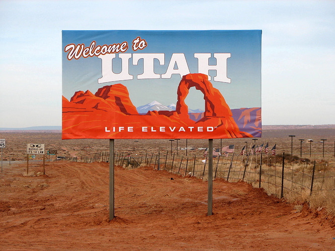
Epic NP sign photo
Springdale is a nice little one-industry town with a host of nice restaurants and hotels. Also, lots of road construction this week. In the 3+ days we were there we watched as an entire new parking lot was brought into existence!
We stayed at the Springhill Suites hotel. After dropping off our stuff we drove up Zion-Mt. Carmel Highway to the tunnel. The tunnel is about a mile long and 1 and a half lanes wide so you often have to wait for big RVs to come through from the other side. That gave me a chance to get some photos.
Mountains to the east and west
On the other end of the tunnel is a trail to the Canyon Overlook. I got a chance to look back on the tunnel on the way up. I made a hacky attempt at a tilt-shift effect here.
Sort of tilt-shifty
Along the way up the trail we ran into a family of bighorn sheep.
Sheep Jam
At least 5 or 6 with a couple of babies. Nobody wanted to tell them to move so we just waited for them to clear out.
Of course, we couldn’t let them go without getting a selfie.
Bighorn Sheep selfie
We got to the lookout about an hour before the sun set behind the western rim of the canyon. It was stunning.
Laura on the Lookout
And a bit scary.
Don’t step back!
But quite pleasant
Sunset
We then drove back into town and got some dinner and back to the hotel. The plan for the next day was to start looking at the Park proper.
Back home
Emerald Pools Hike, Zion
Our first day in the park we decided to go easy on ourselves and start with a short hike to the Emerald Pools
Zion Park has a shuttle system to reduce traffic on the single road that travels from the visitor center north into the canyon. This is extremely convenient as you can park your car in town or at the visitor center and you never have to wait very long for a bus.
The Emerald Pools trailhead starts by the Zion Lodge.
Fancy digs
The trail is a short hike to a couple of cascades. The water levels were pretty low so we didn’t see a lot of water falling action.
More of a trickle than a fall but still pretty
Lower pool trail
There was a middle section above that first falls. I think it had the best views
Looking east across the canyon
Truth
Finally, you can climb up to the upper pool which is surrounded by rock walls on all sides rising 1000 feet. I tried a vertical panorama shot for this.
Upper pool panorama
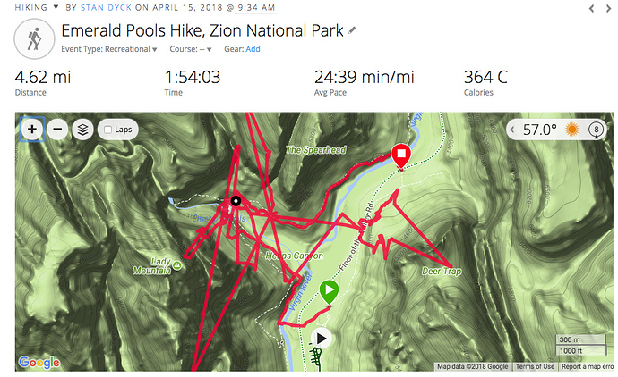
One thing I found in Zion is that the high walls pretty effectively blocked GPS signals. Check out the track for our morning hike to the Emerald Pools
Jittery! The distance is surprisingly accurate though
Looks like I was on the other side of the canyon for a stretch there.
Instead of going back to the trail head, we followed the trail north to the next shuttle stop, The Grotto. The walk gives you good views of the canyon.
Looking south down the Virgin River
Rock walls
The Grotto is where the airy, vertigo inducing Angel’s Landing hike starts, but you need to start that one early and it was lunch time. We grabbed a bite at the Zion Lodge and then took the shuttle up to the end of the road to take the Narrows trail.
Hanging Gardens along the river trail
This trail is one that goes up a mile or two and then reaches a point where if you want to go on, you need to get wet.
Nowhere to go but wet
A lot of people rent hip waders and travel a ways up the canyon. We didn’t do that though. Instead, we turned around,
Walls of rock everywhere
The sun sets early in the bottom of a canyon
A good outdoor dinner back in town and back to bed early so we can get up before the crowds reach the knife edge trail that awaits us.
Angel’s Landing, Zion National Park
Our second full day at Zion we did the Angel’s Landing hike. This is the signature hike at the park and perhaps one of the signature hikes in the entire National Park system.
You can tell it’s serious right away from the sign at the trail head.
Only seven?
It’s not a very long hike and it is nicely paved for the most part but you need to be comfortable with heights. This tourism video gives a pretty good idea what to expect.
The fish-eye lens adds to the effect here
Let’s begin! It looks impressive from below
Between the notch to the left and up to the point in the middle
But we need to get to the top. Onward!
The initial part of the trail is carved into the west face of the canyon and switches back along the wall.
Nicely paved
You climb about half way up the entire height and reach a level section that runs between the Landing and the canyon wall to the south. Refrigerator canyon it’s called; a place where GPS signals go to die. After passing through that you turn around and hit a series of two dozen short switchbacks called Walter’s Wiggles named for a former Park Director who had them built.
Halfway up the Wiggles
When you get to the top of the Wiggles you emerge at Scout’s Lookout. This is your last chance to turn around before the knife edge part of the trail. Even if you don’t have the stomach to go on you still get some impressive views of the canyon below.
Northward view
Over a small rise you pass a final warning sign and then you see it:
Heartrate check
You can follow the trail all the way up in that photo.  Yes, that is the trail. You see the drop off on the left but the one on the right side is just as steep. Notice also the chains. They are placed all the way along so you have something to hang onto. That makes it feel marginally safer.
The drop to the right
One of the difficulties this trail presents is that it is very popular. This means you have to contend with a lot of people sharing the trail going both ways. I didn’t experience this, but I imagine there must be occasions where someone is unable to handle moving forward or backward and creates large traffic jams. It is a good idea to start early so as to beat the larger crowds. In our case, the forecast called for high winds in the afternoon so we had some extra motivation to get off that section early.
Looking back from a wide section
Along the way you are never far from a reminder of how long the drop is
See the bus down there?
We were accompanied by a young couple for a good portion of the way. The man was carrying a small baby on a backpack. They got a lot of remarks from people we passed on the trail. The kid slept the entire way up though.
We had encounters with a dozen or two people coming down but nothing too bad. When we finally emerged at the top there were about a dozen people there.
Summit!

Grabbing a bite at the top (
 looking on longingly)
We got a really tall guy to take a picture of us
Yeah us!


I’m not particularly afraid of heights myself though I think I have gotten more afraid than I was when I was younger. What bothers me more is seeing other people near the edge. I don’t like watching other people taking photos near the edge or sitting close to it. Call it sympathetic acrophobia. Because there were so many people up there, it was quite uncomfortable for me.
This is me looking uncomfortable
I was quite ready to leave. I got a shot on the way down that I think shows the knife edge pretty well. If you click on it and maybe zoom in you can see people all the way along the trail.
Whee!
It feels a little safer on the way back, probably because you more or less know what to expect. I got a shot of Laura on the sharpest part
Drops on both sides
There are 1000+ foot drops on either side of Laura in that photo. I get nervous just looking at that.
Back to relative safety we wandered down the Wiggles and back through the Refrigerator
Pretty
Looking down the canyon
We finished around noon, well before the winds started. We passed a lot of people going up. None of them died  .
.
All in all a very major sense of accomplishment. I earned a nice relaxing afternoon by the pool back at the hotel.
Observation Point Hike, Zion National Park
For our final day at Zion Park we tackled the hike to Observation Point. This is one of the longer day hikes in the park. You start at the floor of the canyon fairly near to where Angel’s Landing is but on the east wall instead of the west.
Observation Point trail head
You start with a steep set of switchbacks going up the east wall. You get good views of the big bend in the river
Big Bend
After quite a bit of climbing you come to a break and you pass through a high walled side canyon.
No more GPS signal
This was the prettiest part of the hike so I’ll just show a few pictures
Nice, eh?
After passing through this lovely area there was another climb along a sheer rock wall.
But at this point you start seeing the canyon from above
Eventually, the trail levels off and you go around the top of the canyon wall to the Point itself. It turns out it is well named.
Observe!
Geological Survey marker in the foreground there
We started the day down there at the bottom
As I said, it is across the canyon from Angel’s Landing. We were well above it in fact. You can see the whole thing in this photo
The top is in the center and the knife edge extends to the right
Here’s one of my favorite shots from the top
Echo!..echo!..echo!..
It was one of the best hikes of the whole trip. Lots of variation in terrain with a huge payoff at the top. If you could only do one hike in Zion I’d pick this one.
After a most wonderful dinner at the Kings Landing Bistro back in Springdale, we were just at sunset so we dashed out to the point where everyone takes the iconic Zion Park Photo ™.
Zion
The plan was to sleep in a little bit and have our last breakfast before driving out to our next destination. Bryce Canyon.
Drive to Bryce Canyon
It’s April 18th. Time to pack up and leave Springdale. Before I do though I need to talk about the Spring Hill Marriott where we stayed. The hotel was real nice, about what you’d expect from that kind of hotel. What really stood out though was this.
Most hotels have free breakfast included. This hotel was no different. They usually have a spread of typical American breakfast foods. Some hot dishes, a toaster with bagels and so forth. What this hotel did the best though was scrambled eggs. They were so good!
It’s not too difficult to make good scrambled eggs if you are just cooking for yourself or a couple of people. It’s a lot harder though when you have to make enough eggs for 3+ hours of hotel guests. Whoever made the eggs at this place got them right every time. I had eggs every morning there and they were always perfect.  So, kudos to the chef!
Ok, so after I loaded up on eggs for the last time we headed east. Back through the same tunnel we went through our first day there.
The drive to Bryce was uneventful. We passed through the east gate of the park. It’s fun to imagine being a pioneer traveler coming from the east for the first time in this fairly ordinary terrain and then suddenly hitting Zion canyon.
There was one turnout we stopped at, still in the Park, in front of a mountain called Checkerboard Mesa.
See why the call it Checkerboard Mesa?
As we approached Bryce we first got to a small taste of what was to come. A place called
Truth in advertising
This was our first look at hoodoos. These are the chimney-like rock formations that are created by erosion.
Hoodoo
This was pretty impressive. But nothing compared to what was to come.
We finally arrived in Bryce Canyon. Here’s a shot of the Park sign to prove it
Bryce Canyon National Park
The elevation at Bryce is around 8000 feet. About twice as high as Zion so the weather was quite a bit colder. It was a cloudless day though so quite pleasant.
Just to the north of the park is a small, one industry town (guess what industry it is) called Bryce Canyon City. We stayed at the Ruby’s Inn. There were a lot of Ruby’s things in the town. Ruby’s Restaurant, Ruby’s Grill, Ruby’s General Store. The Inn is a sprawling place with a grocery, a laundry, space for RVs and hotel rooms and cabins. It’s also right next to the park.
About the park. Here is a map
You can see it is long and wide. The entrance is at the north and there is a single road running to the south end. All the cool stuff is on the east side and all the coolest stuff is on the north end.
The way to see the park then if you are driving is to go all the way to the south end and then make your way back up north stopping at all the turnouts on the right hand side as you drive back. This means you get all the best stuff at the end and if you time it right you end at or close to sunset so you get the most dramatic photos. That is what we did.
The nice thing about doing this is that you continually see things that are more impressive than the last thing you saw. At the southern end of the park is Rainbow Point
and Yovimpa Point
Then Black Birch Canyon
At Ponderosa Canyon we ran into this guy
Nevermore!
He/She was convinced that we were the kind of people that were going to drop some food. Instead we just had a bit of fun at his/her expense.
Now who is the trickster, huh?
Further up the road is a place called Natural Bridge
They are real good with names around these parts
There’s a little rock formation under the bridge called Yoda, but it was in shadow here so I didn’t get a good picture of it. Trust me, it did look a lot like Yoda.
So far everything has been beautiful. Well worth seeing, but now we started to get towards the north end. Things started to get more dramatic
Paria View
What’s this now?
And then you hit the place called the Amphitheater and everything that you saw before is forgotten.
Bryce Point
A Hoodoo Host
When I was a kid we had these National Geographic books that had photos of many of the National Parks. It had pictures of Bryce Canyon and I remember seeing them and not really believing it was an actual place. Well, I’m here to tell you it does exist and photos really don’t do justice. You need to go there and see for yourself. I’ll just stop writing and do my best to convince you via pretty pictures.
The Wall of Windows
Inspiration Point
Thor’s Hammer
Wave at Laura
Sunset Point
This is what we paid to see. Really just an indescribable experience.
The sun was beginning to set so we headed back to the hotel. We had dinner at a great restaurant a few miles out of town called the Stone Hearth Grille. I had a most excellent steak.
After a day of viewing on 4 wheels the plan for the next day was to spend some time on 2 feet. A hike among the hoodoos.
Peek-a-boo Hike, Brice Canyon
I did!
For our second day at Bryce Canyon we wanted to get out of the car and do some hiking. We decided on the Peek-a-boo loop trail starting from Bryce Point. It’s about 5 miles with enough elevation gain to get your heart rate up.
It was a partly sunny day that started out a bit cool. The hike starts at the top of the canyon and descends into amphitheater.
The first mile drops about 500 feet.
On the way down
Laura included for scale
After the first mile you reach a fork. This is where the loop starts. We went counter-clockwise
Exit to the left (with the Wall of Windows in the background)
The trail is also available to horses so there is a horse stabling area (is that what you’d call it?) at the beginning of the loop. There is also an area above called the Wall of Windows
Wall of Windows
The left path is closer to the canyon wall so the wall looms up above
The trail does a lot of roller coaster up and down.
As you loop around there are some interesting hoodoos and other rock formations
This one kind of looked like the Acropolis to me
Eventually, you get back to the fork which means you have a mile long climb to get back to the trail head.
That point in the background, waaaay up there, is where we started
Things looked a bit different on the way back because the sun had come out
Holy rock wall, Batman!
Kinda looks like a camel?
Back at the top, I went to the Bryce Point lookout to look down on where we had been
You can make out a lot of the trail if you look closely
Such a pretty place
Click to look closer
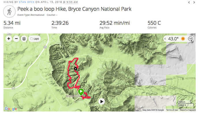
This is the GPS track for the hike.
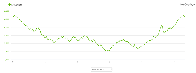
Here’s the elevation profile
Bryce Canyon to Las Vegas
Our last day we woke up to about an inch of snow on the ground. We were scheduled to spend the night in Las Vegas. Rather than start out immediately, we decided to head into the park to take a look at some snow covered hoodoos.
Just a dusting
You can see there wasn’t a lot of snow but it made things look a little different.
The temperature was right at freezing and the weather forecast didn’t look all that great for the trip home so we high tailed it out of Bryce and headed for warm, sunny Nevada.
The trip back through Utah was an adventure.
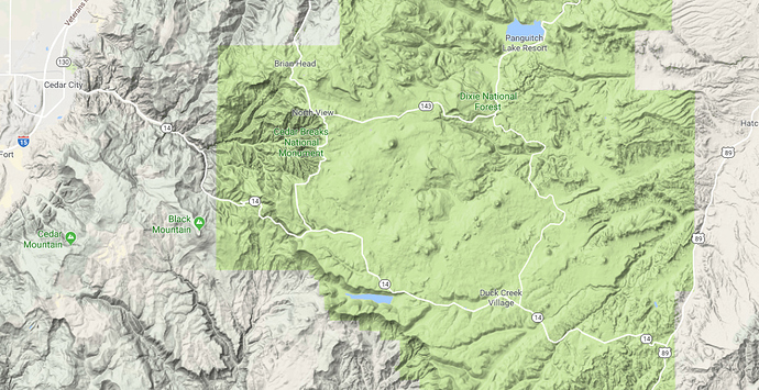
We came down highway 89 on the right. The GPS had me turn off at route 14 to go across the Dixie National Forest to the Interstate at Cedar City. This was fine until we got to Duck Creek Village. We kept gaining elevation and the temperature kept dropping and soon the steady rain turned to snow. First it was just dusting the road but it got thicker as the temperature dropped to the low 20s. We finally crested the pass and the temperature started to climb again but it was even more treacherous because there were 7-9% grades on twisty roads covered with snow. Of course our Las Vegas rental car had no chains and no 4WD so we were just forced to go real slow.
I took some comfort in the fact that we had a couple of cars behind us so if we got in real trouble we’d have people to help out but it was some white knuckle driving for sure. All things considered, we would have been better off going further south to go back through Zion.
We did make it though. The road from Cedar City was quite rainy and still a bit stressful but when we dropped down to the Nevada/Arizona border it cleared up and the temperatures were back in the 70s. It was windy but by the time we hit Las Vegas it was hot. A huge change in weather for a single day.
Las Vegas of course is a different from Bryce Canyon is other ways besides weather.
A little Italy…
…a little Paris…
I dunno, kinda Vatican-y?
Ferris Wheel. Alas! booked solid for the evening.
But lots of people everywhere. Las Vegas is not really my kind of place. I don’t gamble and I’m not into most of the entertainment options but it is definitely fun in small doses. One night was perfect for me. We did a lot of walking up and down the Strip with plenty of people watching.
We spent the night at The Venetian. One nice thing about Las Vegas is you can very often get great deals on hotel rooms. We had easily the nicest room of the whole trip and it was also the cheapest.
The Venetian, as you might expect has an Italian theme to it. The inside is made up to look like a nice Italian piazza in perpetual, air-conditioned twilight
Complete with indoor canals
We had a nice dinner and headed out for some nighttime walking.
The Bellagio Fountains
We were right across the street from the volcano at The Mirage hotel. We saw all three times it blows, the first from our hotel room, the second up close and the third from across the street. It always seemed kind of cheesy when I’ve seen it on TV but I have to admit it is pretty cool in person. Hard to believe it has been around since 1989.
The next morning, we got up and headed to the airport and from there back to Seattle. The day we left was one of the rainiest of the year and we came back to much nicer weather so I think we picked a perfect time to get out of western Washington. All in all it was an immensely satisfying and enjoyable trip. Happy Birthday, Laura! I hope to have many more birthdays and many more great trips with you.
